Quick Summary
- Work starts in August at the east end, to increase flow
- Project calls for 5 weirs along a 15-inch elevation drop
- Lower pathway to be renovated
Maybe you’ve seen the signs asking, “What’s up with the Arboretum Waterway?” — referring in part to the unsightly duckweed and algae that thrive in what is largely a stationary body of water.
Public Meeting
An information session on the Arboretum Waterway Maintenance and Enhancement Project Is scheduled from 6 to 7:30 p.m. Wednesday, June 29, on the Wyatt Deck(in the arboretum, overlooking the waterway and Lake Spafford). Brief project overviews will be given at 6:15 and 7 p.m. Participants also are invited to speak with experts involved in the planning, and preview the designs.
Online resources
- Arboretum Waterway Maintenance and Enhancement Project
- Frequently asked questions
- Stay informed! Sign up to receive The Leaflet, the UC Davis Arboretum and Public Garden’s e-newsletter.
The signs also describe a multiyear improvement project. Now that effort is about to get underway.
“To improve the overall aesthetics of this iconic part of our campus environment and combat the rapid growth of both these naturally occurring, water-loving organisms, we need to improve the water’s flow,” reads an article on the UC Davis Arboretum and Public Garden’s website.
For those who don’t know, the waterway is not a creek — it’s a large pond that is dammed on both ends, hence the slow flow. The waterway sits in the channel that used to be the North Fork of Putah Creek, which flowed east toward downtown Davis. In the 1870s, after frequent floods, townspeople and farmers diverted the creek.
Today, the campus manages the waterway as a holding pond for storm runoff; as a receptacle for clean, recycled water (which assists flow in the west end); and as the centerpiece of the arboretum — trees and plants line the waterway, and paths run on both sides, the entire length. But there’s that problem of limited flow. (The water flows east to west, opposite the channel’s original direction, to a weir; when the water is high enough, it goes over the weir and into a pump that sends the water to the South Fork of Putah Creek.)
“We’re excited to move forward on this project not only because it’s going to be safer, more accessible and lower maintenance — it’s also going to look better,” said Assistant Vice Chancellor Bob Segar, campus planner.
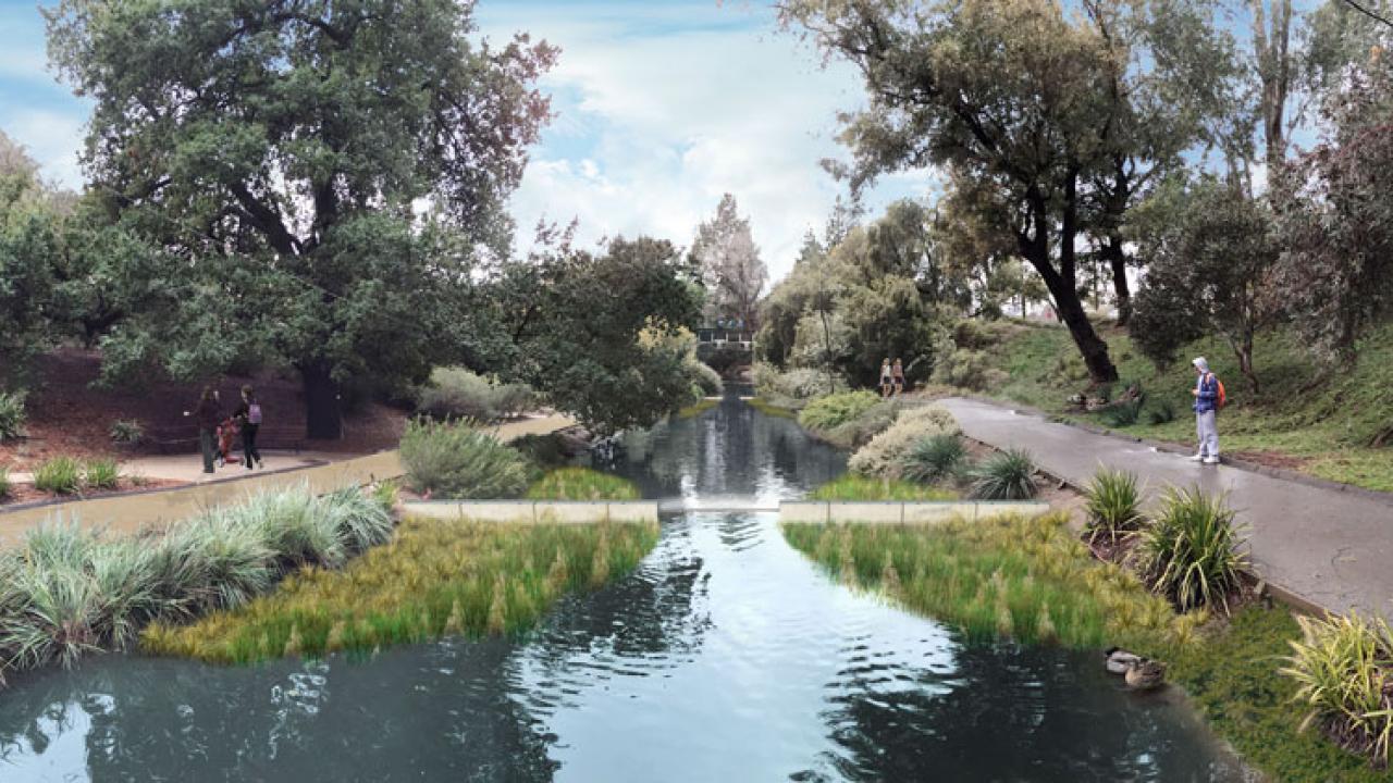
‘Water cascading down’
The campus envisions a four-phase improvement project, starting with the east end of the waterway — between the dam at the east end and the Wyatt Deck Bridge on the east side of Lake Spafford. “In order to create flow in this part of the waterway, we will introduce small elevation changes via weirs — barriers across water that alter its flow characteristics,” the information page states. “Picture a series of large, natural steps with water cascading down.”
A pilot project showed the system will work, said Andrew Fulks, assistant director of the Arboretum and Public Garden. “Now we have the opportunity to implement that plan on a larger scale,” he said.
Water in the east end will be recirculated; that is, at the point where the east end dumps into Lake Spafford, a pump (in a vault and inaudible) will send water back to the far east end.
Officials said Phase 1 will begin in August with the construction of a cofferdam near Wyatt Deck to separate Lake Spafford from the east end of the waterway. Aquatic wildlife (turtles, fish, etc.) will be moved to Lake Spafford before the construction starts.
Then, the east end will be drained, given time to dry out, and dredged to remove excess sediment. A 15-inch elevation drop will be engineered, and five weirs constructed. They will be concrete with steel lips over which the water will flow. Only about six inches of each weir will be visible above the water, so the weirs will be small relative to the creek banks.
The project also calls for strengthening the waterway’s banks, transforming them from rock and wire baskets to earth slopes that are planted with native vegetation.
Brick pathway to be extended
Phase 1 also includes a renovated pathway on the south side of this area to meet the Americans With Disabilities Act. “Look for the brick pathway that begins in the Arboretum GATEway Garden (behind the Davis Commons shopping center) to extend all the way to the T. Elliot Weier Redwood Grove,” according to the project information page.
During construction, according to the project’s FAQs, detours for bikes and pedestrians will be in place when the lower pathways are inaccessible.
“There is the possibility of some odor of decaying material as the work area is drying out. Through the use of pumps to remove the water quickly, odors will be minimized by speeding the drying.”
The weirs and new path are scheduled for completion by the end of this calendar year. This phase of the waterway project is made possible through deferred maintenance funds from campus.
The project’s FAQ page outlines the remainder of the project: “The long-term plan (over the next four years) is to create the same type of recirculation and weir system to the west, continuing to the Putah Creek Lodge. From the Putah Creek Lodge to the western terminus of the waterway, the plan is to create an emergent marsh, open water and riparian forest habitat area which will increase the wildlife habitat dramatically. This area is also planned to have a boardwalk and viewing platforms.”
Media Resources
Dateline Staff, 530-752-6556, dateline@ucdavis.edu