UC Davis is preparing to debut a new campus map — make that two maps.
One is the traditional paper map in pads of 50 and as single, folded copies, just the right size to put in a No. 10 envelope. The map is smaller than previous versions and it includes advertising for the first time. But, on the plus side, the ad revenue is paying for the maps — and they will be in color for the first time.
The campus has ordered 120,000 copies; also, you will be able to print it yourself, on your own computer.
The second new map is an online version, Google-based, with some nifty features:
• Pop-up boxes with building photos and links to related campus websites, where you can get detailed information about places and programs.
• An easy way to retrieve Google directions, so you can find out how to get to the parking lot or garage that is closest to where you want to go on campus.
• Icons that show accessible entries (i.e., wheelchair ramps) and power-assist entries (where you can push a button, and a door opens automatically).
• An easy way for campus units to link from their websites to the map — not to the map in its entirety, but to your unit’s specific location on campus.
The online map is here. As of Sept. 7, the home page link to “campus map” (under Quick Links) will take you to this new version.
New printed map pays for itself
Bob Segar, assistant vice chancellor for Campus Planning and Community Resources, said the new maps — in print and online — are tools that will help UC Davis boost its profile and visibility.
“Given budget constraints, we were going to eliminate free distribution of the black-and-white campus map,” Segar said. “By redesigning the map and offering the opportunity for campus units and visitor-related businesses to advertise, we produced a more visitor-friendly color map that completely pays for itself.”
The new color maps, like the old black-and-white maps, are free. See below for information on how to get them.
At the same time, the campus decided to produce a new online map “to greatly assist the campus community and visitors with way-finding,” Segar said.
“The Davis campus can be complicated to navigate, and this map can be continually improved and kept up to date.”
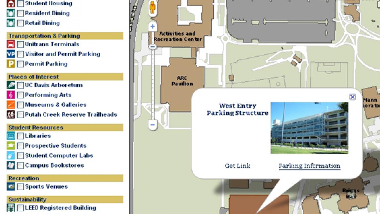
The online map’s index includes a list of buildings, in a drop-down menu, plus other places of interest — from libraries and student computer labs, to the arboretum collections and Putah Creek Riparian Reserve trailheads.
Pop-up boxes show buildings, provide links
When you click on anything in the index, a pop-up box identifies the site’s location on the map. Each box gives the name of the building or other place of interest, and, in most cases, a photo.
Each pop-up box also provides a Web link, if there is one, to more information. For example, the Segundo Residence Halls pop-up box includes a link to Student Housing, and each link for a Unitrans terminal includes a link to the Unitrans website.
“We are trying to give people as much information as we can from one spot,” said Chris DiDio, geographical information system specialist with the campus’s Administrative and Resource Management.
He and ARM colleague Andrew Fulks, manager of the Putah Creek Riparian Reserve, came up with the concept for the new online map. Joshua Babcock with Repro Graphics handled the programming, and DiDio was the project manager.
One of their challenges was dealing with a campus that does not generally use street addresses (except for 1 Shields Ave.) and which restricts automobile traffic in the inner core.
Therefore, most visitors who need directions will need to know how to get to parking lots and garages. The new online map identifies 27 of them — marked by "VP" icons — when you click on "Visitor and Permit Parking" in the index. By clicking on any of the "VP" icons, you will bring up a pop-up box for that parking lot or garage — and within each pop-up box you will see two links, one for directions “to here,” the other for directions “from here.”
Google directions to nearest parking lot
These links take you to Google Maps, which will give you the directions you need — even though your chosen parking lot or garage has no street address. Google works around this by automatically inserting the geographic coordinates for the parking lot or garage, as either your destination or your starting point.
The new online map replaces one that is about 5 inches square. You can enlarge it, but only one section at a time — which means that you cannot see any of the enlarged sections in context with the rest of the map.
The new, Google-based map allows you to zoom in (and out), and, by using the hand icon cursor, you can move the map every which way, to show more of the campus in the direction you are going.
DiDio said he hopes the new online map will become the map of choice for units that include one on their websites. This can be easily done:
Each pop-up box includes “Get link” — click on it, and the URL pops up for that specific section of the map. Copy the URL and paste it into your website to make your own link; then, when someone goes to your website and clicks on “map,” they will be taken to the appropriate section of the campus map, showing your building. Here is an example for Mrak Hall.
More manageable size
The completely redesigned printed map, the work of Repro Graphics art director Andrew Larsen, is a more manageable 12 inches by 18 inches, compared with 14-by-18 inches, roughly, for the old map. The smaller size covers only the central campus, leaving out the south campus and other outlying facilities.
“The old map was a funky size,” said Lina Layiktez, director of Conference and Event Services. “By shrinking it slightly, we made it printer-friendly.”
The printing option is not yet available — but, when it is, you will able to print it in a slightly reduced size on tabloid paper (11-by-17) or even smaller on three sheets of 8½-by-11-inch paper. “It’s more visitor-friendly all the way around,” Layiktez said.
The advertising, she said, is tasteful: 27 ads from a number of campus units (including Transportation and Parking Services, the bookstore, the Activities and Recreation Center, and the Cal Aggie Alumni Association) and from hotels and such organizations as the Davis Downtown Business Association.
Here’s how to order
Maps can be ordered online through myprint.ucdavis.edu. Create a UserID and password or log in if you already have one. Search the catalog for “Campus Maps,” then select the desired quantity of flat or folded maps. Add to cart and then place your order. The system requires valid billing information, but you will not be charged for these maps. Then, after Conference and Event Services approves your order, Repro Graphics will deliver your maps.
Questions should be directed to Amy Harris by email or phone, 530-754-1014.
Media Resources
Dave Jones, Dateline, 530-752-6556, dljones@ucdavis.edu